CityGML
Applications, Open Data and Open Source Tools
Richard Redweik & Stefan Lüdtke
22. - 23. November 2015
Agenda
Thursday: General introduction into tools and workflows
Friday: Practical hands-on session
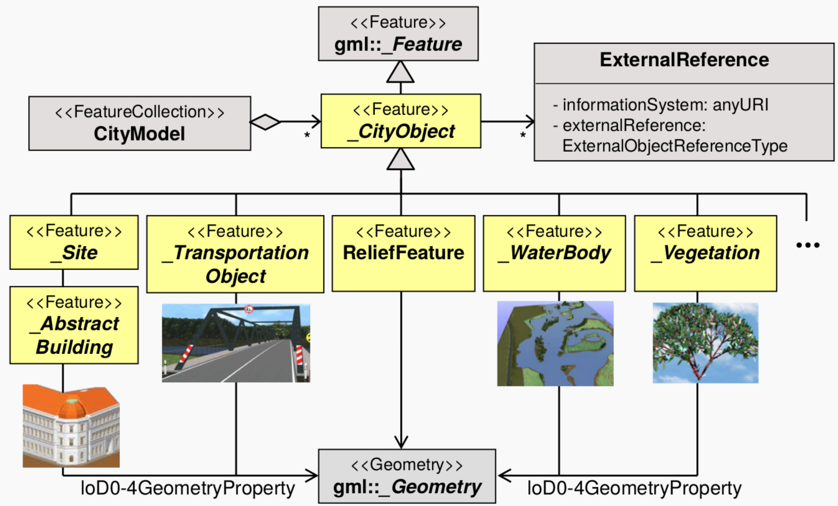
CityGML Recap
Application independent geospatial information model
International OGC standard
Different thematic areas (buildings, water, vegetation, bridges etc.)
CityGML represents
- 3D geometrey, 3D topology, semantics, and appearance
- in 5 discrete scales (levels of detail, LOD)
Data model (UML) and exchange format (based on GML3)
CityGML Thematic Modelling
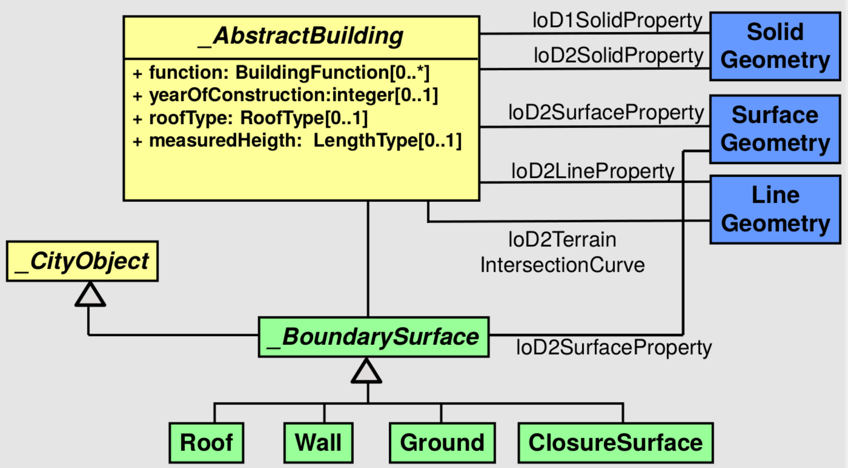
Example: Building Model
Coherent aggregation of spatial and semantical components
(Recursive) composition of building parts
Thematic surfaces (roof, wall, etc. surfaces) [from LOD2]
Building installations (stairs, balconies) [from LOD2]
Openings (doors, windows) [from LOD3]
Rooms and furniture [from LOD4]
Building Model LOD2 - UML Diagram
However!
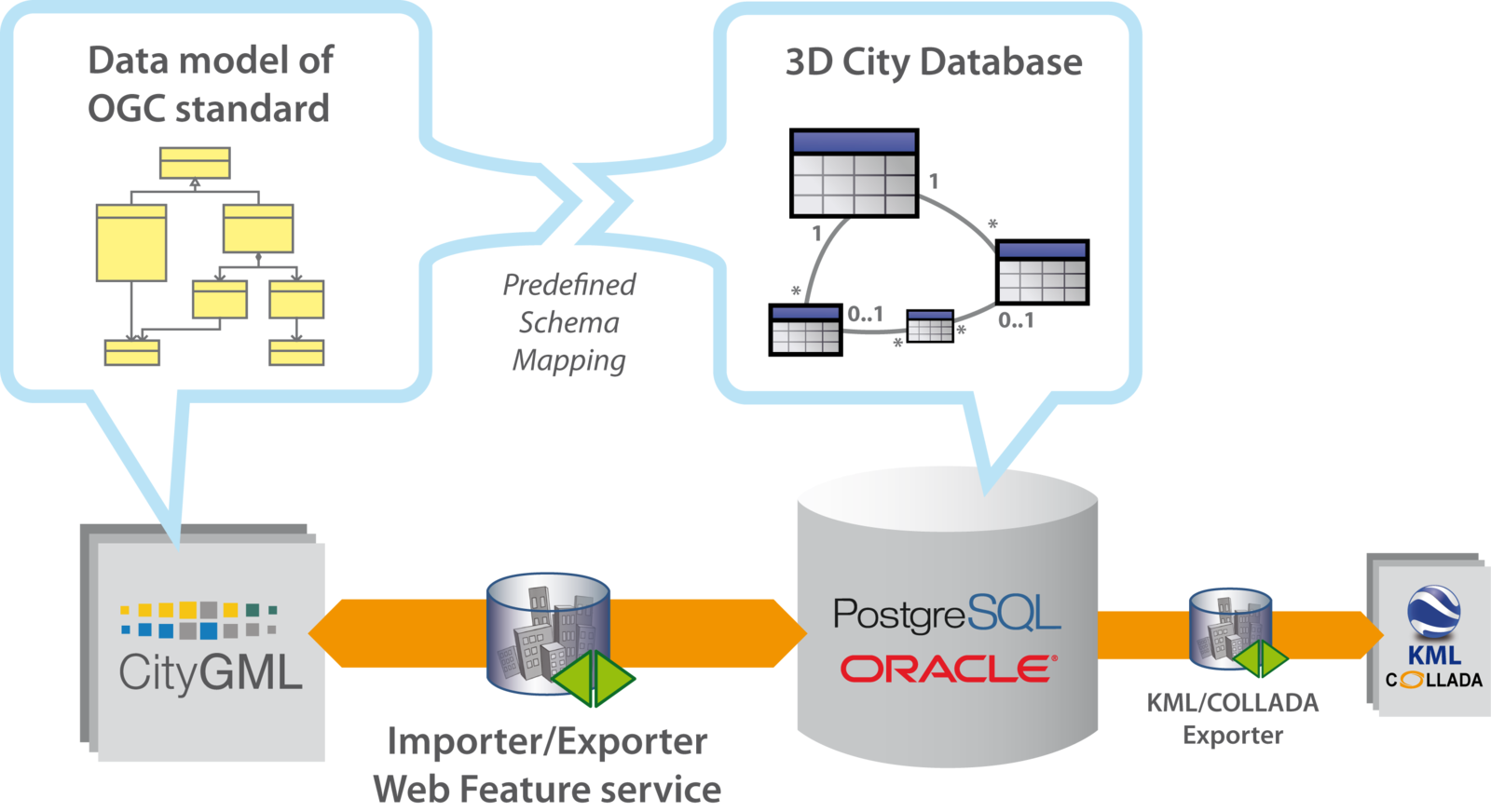
CityGML datasets may become very large
--> Use database to work with!
Need for Database? Some Examples!
Multiple simultaneous changes to data (concurrency)
Data changes on a regular basis
Large data sets where you only need some observations/ variables
Share huge data set among many people (data consistency in a working group!)
Rapid queries
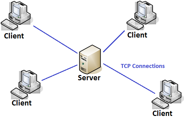
Web interfaces to data, especially dynamic data
Databases
Data bases are collections of tables (2D with columns and rows)
Very good for combining information from several tables
E.g., select all buildings located in Berlin
| ID | Name | Population |
|---|---|---|
| 1 | Berlin | 3502000 |
| 2 | Potsdam | 159456 |
| ID | City | Height |
|---|---|---|
| 1 | 1 | 10.0 |
| 2 | 1 | 22.2 |
| 3 | 2 | 15.0 |
Used Tools
3D City Database (3DCityDB)
3D City Database Importer/Exporter
pgAdmin
QGIS
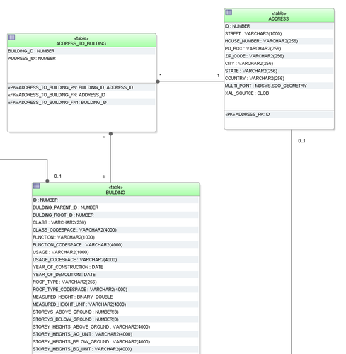
3DCityDB - Overview
3DCityDB - Details
Free 3D geo database
Enables to store, represent, and manage virtual 3D city models
Realized as relational database schema for:
- PostgreSQL/PostGIS
- Oracle Spatial
Don't be afraid!
May appear complex in the beginning (60 tables)
But!
Tables are strucuted logically
You probably do not use all tables
--> 3DCityDB not as complex as it seems!
3DCityDB - Building Schema
Subset of the building schema
PostgreSQL
Relational Database Management System (RDBMS)
Open Source
Strong reputation for reliability, data integrity and correctness
Very good documentation
Runs on Linux, Unix (MacOS, BSD), Windows
pgAdmin as GUI for administration
SQL
- Structured Query Language
- Language to save, edit and query data in relational data bases
- First version in 1974 (IBM)
- Became a standard of the American National Standards Institute (ANSI) in 1986
- Revised in 1999: SQL99 or SQL3
- SQL has standards but also some pecularities depending on the database management system
- Used to 'talk' to the database server
- Used as front end for postgresql
- Case sensitive (usually upper case for keywords)
Ways to use SQL
Console command (psql -h hostaddress -U db_name)
GUI (pgadmin)
Interfaces to programming languages (R, python, Java, etc.)
SQL Syntax - I
Create Database
CREATE TABLE measurements (id BIGINT NOT NULL DEFAULT, date TIMESTAMP WITH TIME ZONE, value DOUBLE PRECISION);Insert Data
INSERT INTO mesurements
VALUES('2014-09-01', 10.456);
Edit Data
UPDATE measurements
SET value = value + 1;
SQL syntax - II
Query Data
SELECT value
FROM measurements;
Comparison/Filter
SELECT value
FROM measurements
WHERE date > '2013-01-01';
Summary and Computations
SELECT MAX(value) AS max_val
FROM measurements
WHERE date > '2013-01-01'
PostgreSQL
Includes most SQL:2008 data types, including INTEGER, NUMERIC, BOOLEAN, CHAR, VARCHAR, DATE, INTERVAL, and TIMESTAMP
Supports storage of binary large objects, including pictures, sounds, or video
Diverse native programming interfaces (C/C++, Java, .Net, Perl, Python, ... )
Key features
| Limit | Value |
|---|---|
| Database Size | Unlimited |
| Maximum Table Size | 32 TB |
| Maximum Row Size | 1.6 TB |
| Maximum Field Size | 1 GB |
| Maximum Rows per Table | Unlimited |
| Maximum Columns per Table | 250 - 1600 depending on column types |
| Maximum Indexes per Table | Unlimited |
Architecture
SQL
- Structured Query Language
- Language to save, edit and query data in relational data bases
- First version in 1974 (IBM)
- Became a standard of the American National Standards Institute (ANSI) in 1986
- Revised in 1999: SQL99 or SQL3
- SQL has standards but also some pecularities depending on the database management system
- Used to 'talk' to the database server
- Used as front end for postgresql
- Case sensitive (usually upper case for keywords)
Ways to use SQL
Console command (psql -h hostaddress -U db_name)
GUI (pgadmin)
Interfaces to programming languages (R, python, Java, etc.)
SQL Syntax - I
Create Database
CREATE TABLE measurements (id BIGINT NOT NULL DEFAULT, date TIMESTAMP WITH TIME ZONE, value DOUBLE PRECISION);Insert Data
INSERT INTO mesurements
VALUES('2014-09-01', 10.456);
Edit Data
UPDATE measurements
SET value = value + 1;
SQL syntax - II
Query Data
SELECT value
FROM measurements;
Comparison/Filter
SELECT value
FROM measurements
WHERE date > '2013-01-01';
Summary and Computations
SELECT MAX(value) AS max_val
FROM measurements
WHERE date > '2013-01-01'
PostGIS
Spatial extension for PostgreSQL
Support for spatial objects (geometry, geography, raster)
Spatial predicates (interaction of geometries)
- Spatial operators
- Measurements (area, distance, length, etc.)
- Set operations (union, difference, etc.)
Multi-dimensional spatial indexing
PostGIS - Example
Select cities with certain area and population
SELECT name, pop FROM cities
WHERE pop < 300000
AND ST_Area(cities.the_geom) < 400000000;
Select houses located in the suburbs
SELECT houses.*
FROM houses, suburbs
WHERE ST_Intersects(houses.geom, suburbs.geom);
Additional Data Type for Geometry
The geometry is stored in a extra column, usually termed geom or the_geom, all based the following link
Uses Well-Known Binary (WKB) and Well-Known Text (WKT) Representations defined by OGC
- Example WKB:
- POINT (10 10)
- LINESTRING (10 10,20 20,30 40)
- POLYGON ((10 10, 10 20, 20 20, 20 15, 10 10))
- MULTIPOINT ((0 0),(1 2))
- MULTILINESTRING ((0 0,1 1,1 2),(2 3,3 2,5 4))
PostGIS provides
Processing and analytic functions for both vector and raster data (e.g. splicing, dicing, morphing, reclassifying, and unioning)
Raster map algebra
Functions for spatial reprojection
Support for ESRI shapefile vector data (+ more formats via 3rd-party tools)
- Importing data from many standard formats
- Raster data (GeoTiff, NetCDF, PNG, JPG, ...)
- Vector data (KML,GML, GeoJSON, GeoHash and WKT)
PostGIS provides (cont.)
Rendering raster data in various standard formats GeoTIFF, PNG, JPG, NetCDF, ...
Seamless raster/vector functions for extrusion of pixel values by geometric region, running stats by region, clipping rasters by a geometry, and vectorizing rasters
3D object support, spatial index, and functions
Network topology
PostGIS as a GIS
- PostGIS offers full GIS functionality ...
- reprojection
- area calculations
- intersect, union, merge ...
- ... among all data-types
- all vector types supported (point, line, area ...)
- raster layers supported as well
- and standard interfaces for visualization
- QGIS, GRASS spatial layers from a Postgres DB out of the box
- ArcMap is supposed to do so as well
PostGIS Functions
- '
ST_' prefix (Convention for spatial type) Functions to work with the geom column
Getting the CRS of the table/layer
SELECT ST_SRID(geom)
FROM catchments;
Re-project geometry into a different CRS
UPDATE subbasins
SET geom = ST_TRANSFORM(geom, 4326);
PostGIS - Example
Select cities with certain area and population
SELECT name, pop FROM cities
WHERE pop < 300000
AND ST_Area(cities.the_geom) < 400000000;
Select houses located in the suburbs
SELECT houses.*
FROM houses, suburbs
WHERE ST_Intersects(houses.geom, suburbs.geom);
3D City Database Importer/Exporter
Front-end for 3D city database
Allows importing and exporting of CityGML data into/from 3DCityDB
Allows export in KML and COLLADA for visualization
Offers GUI and CLI
3DCityDB-Overview
QGIS
Previously known as Quantum GIS
Open source Geographic Information System (GIS)
Integration of PostGIS and GRASS
Runs on Linux, Unix, MacOS, Windows, Android
Supports many vector, raster, and database formats and functionalities
Customizable via plugins (C++, Python)
3D City Model Berlin
550.000 buildings on about 890 sqkm
LOD2 building models with facade textures
Can be downloaded and used as part of Berlin's Open Data Initiative
Berlin 3D - Download Portal
Data modelling
is fundamental for efficient
- storage of data
- data maintenance
- work with data
Database normalisation
Normalisation is the formalisation of the design process of making a database compliant with the concept of a Normal Form.
It addresses various ways in which we may look for repeating data values in a table.
There are several levels of the Normal Form, and each level requires that the previous level be satisfied.
The normalization process is based on collecting an exhaustive list of all data items to be maintained in the database and starting the design with a few "superset" tables.
Normalisation- First Normal Form
For best results, start with a reasonable breakdown of all attributes in different tables
Reduce entities to first normal form (1NF) by removing repeating or multivalued attributes to another, child entity.
Basically, make sure that the data is represented as a (proper) table.
While key to the relational principles, this is somewhat a motherhood statement.
Normalisation- First Normal Form
However, there are six properties of a relational table (the formal name for "table" is "relation"):
- Entries in columns are single-valued.
- Entries in columns are of the same kind.
- Each row is unique.
- Sequence of columns is insignificant.
- Sequence of rows is insignificant.
- Each column has a unique name.
The most common sins against the first normal form (1NF) are the lack of a Primary Key and the use of "repeating columns."
Normalisation- Second Normal Form
Reduce first normal form entities to second normal form (2NF) by removing attributes that are not dependent on the whole primary key.
The purpose here is to make sure that each column is defined in the correct table. Using the more formal names may make this a little clearer. Make sure each attribute is kept with the entity that it describes.
Normalisation- Third Normal Form
Reduce second normal form entities to third normal form (3NF) by removing attributes that depend on other, non-key attributes (other than alternative keys).
This basically means that we shouldn't store any data that can either be derived from other columns or belong in another table
* for more background and guidance code guru
Hands-On
Create Database
Create 3D City Database
Import City Model
Inspect Database with pgAdmin
Export building data with QGIS
Thursday!
Export building data with QGIS - I
Query:
WITH
groundSurfaces AS (
    SELECT thematic_surface.*
    FROM citydb.thematic_surface INNER JOIN citydb.objectclass
    ON objectclass.id = thematic_surface.objectclass_id
    WHERE classname='BuildingGroundSurface'
),
surfaceGeometries AS (
    SELECT *
    FROM citydb.surface_geometry INNER JOIN groundSurfaces
    ON groundSurfaces.lod2_multi_surface_id = surface_geometry.parent_id
    WHERE geometry IS NOT NULL
),
heights AS (
    SELECT measured_height, surfaceGeometries.*
    FROM citydb.building INNER JOIN surfaceGeometries
    ON building.id = surfaceGeometries.building_id
)
SELECT row_number() OVER() As id, building_id,
measured_height, ST_Force2d(geometry) AS footprint FROM heights;
Export building data with QGIS - II
Export building data with QGIS - III
Eddy Footprint with 3D City Model
Footprint provided by Gerardo Fratini!
Outlook LoCaL
Low Carbon City Lab

Outlook LoCaL
Architecture 
Outlook LoCaL
Information View 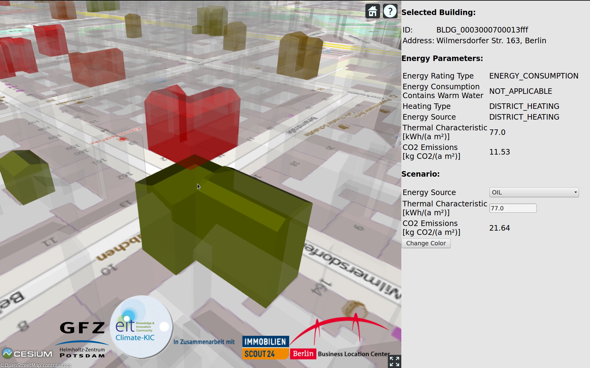
Questions?
Focus for tomorrow?
CityGML - Applications, Open Data and Open Source Tools
Friday!
Slides Online
Open presentation so that you can copy paste needed commands!
We owe you something!
Eddy Footprint with 3D City Model
Footprint provided by Gerardo Fratini!
Recap: Need for Database? Some Examples!
Multiple simultaneous changes to data (concurrency)
Data changes on a regular basis
Large data sets where you only need some observations/ variables
Share huge data set among many people (data consistency in a working group!)
Rapid queries
Web interfaces to data, especially dynamic data
Hands-On
Start Virtual Machine
Create Database
Create 3D City Database
Import City Model
Inspect Database with pgAdmin
Export building data with QGIS
Start Virtual Machine
Open VirtualBox
Import virtual machine:
- 'File' > 'Import appliance'
- Select downloaded .ova file
- Click 'Next', then 'Import'
Start virtual machine
- User: ghg
- Password: potsdam2015
Create Database
Remember:
We use PostgreSQL as database management system
Open source
SQL based
Use it by console, GUI (pgAdmin), or programming interfaces (R, Python, Java, ...)
PostGIS adds spatial functionalities
Create Database
Execute following statement as PostgreSQL admin:
CREATE DATABASE ghg_handson
WITH OWNER = ghg;
... and to enable PostGIS:
CREATE EXTENSION postgis;It is already done on the VM! \o/
Create 3D City Database (3DCityDB)
The 3DCityDB is a relational database schema
Schema results from a mapping of the object-oriented data model of CityGML to the relational data model of the RDBMS
Schema is like a 'blueprint' of the database
That means, the database structure is created, no data is added!
To create 3DCity DB:
Start 'Terminal Emulator'
cd /home/ghg/Documents/3DCityDB-3.0.0-postgis/PostgreSQL/SQLScripts/
psql ghg_handson -f CREATE_DB.sql
Specify Spatial Reference System
Coordinates of Berlin's city model defined in:
- EPSG:25833
- ETRS89 / UTM zone 33N
Setup requires user input:
- Spatial Reference Identifier for geometry objects (SRID):
25833
- GML conformant URN encoding for gml:srsName attributes:
urn:ogc:def:crs,crs:EPSG::25833,crs:EPSG::5783
Import City Model
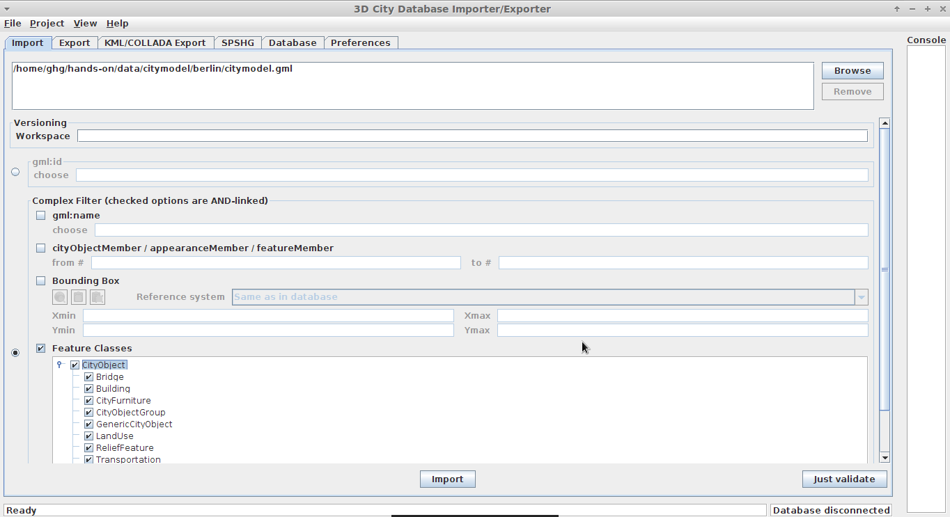
Start 3D City Database Importer/Exporter

Connect to Database
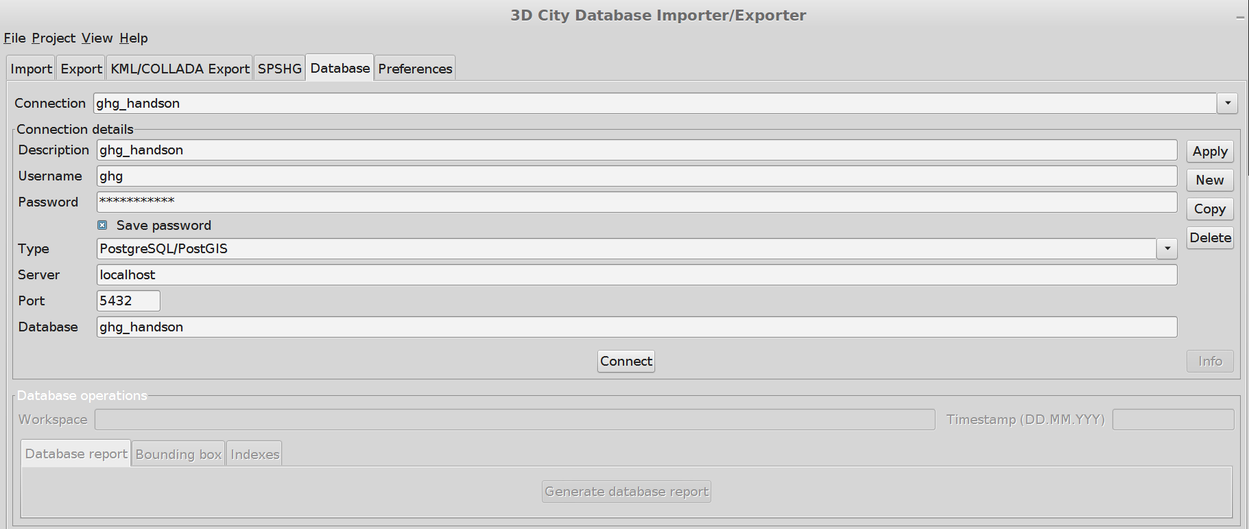
Do the import
Path to CityGML file:
~/Desktop/ghg_flux_ws/city_gml/hands-on/data/citymodel/berlin/
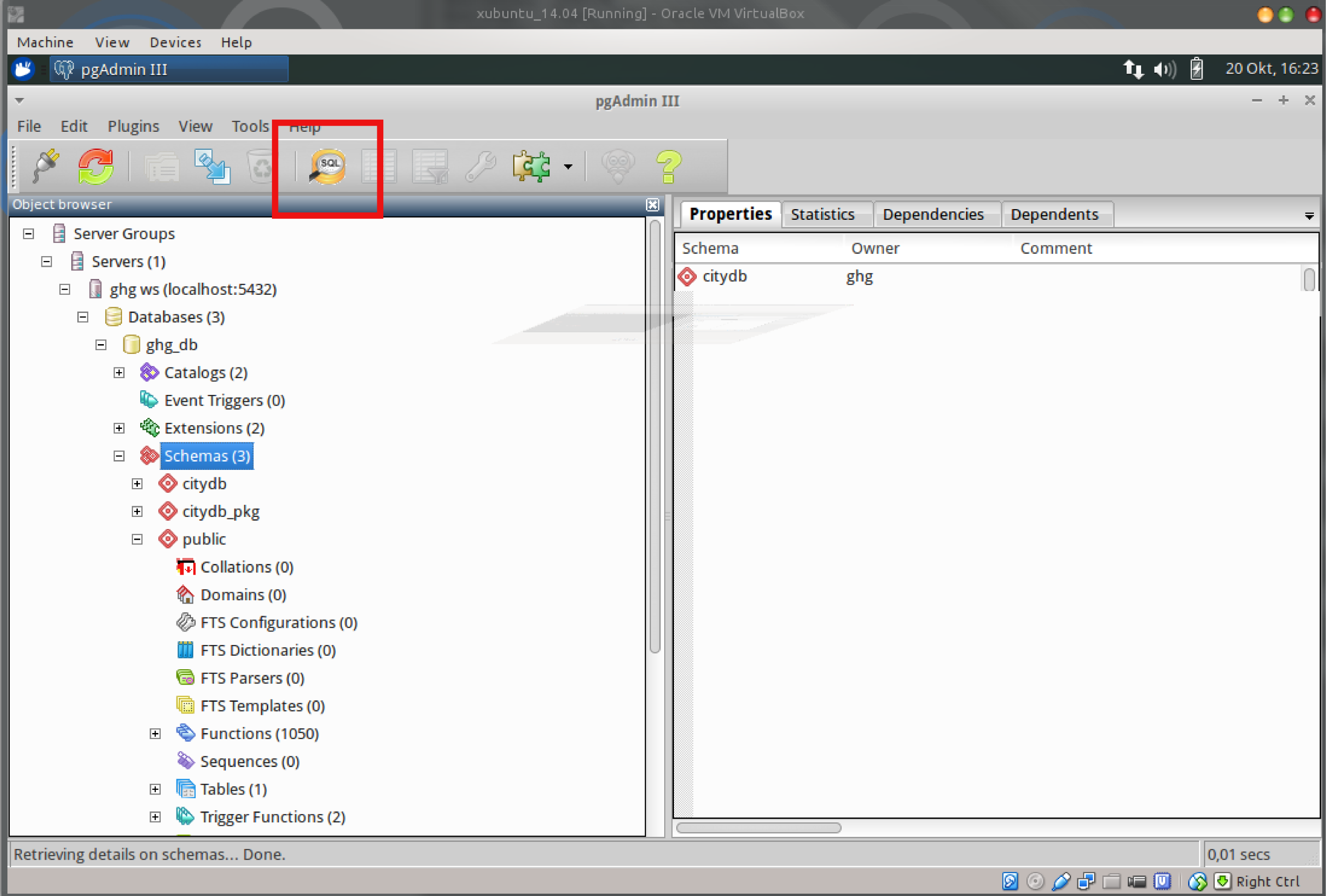
Play around with pgAdmin
pgAdmin provides an interface/gui to:
- Administration of the DB
- Server administration and configuration (pg_hba.conf, postgresql.conf)
- user and group management
- setup privileges (permissions what user can do and can not do
- Query the DB
- Graphical query builder
- sql window
Query the DB
Ask for all building greater than height X
Open the sql-query window
Graphical query builder
Similar to DB connectors shipped with common Office suites (e.g. MS the evil Office and Librethe brave Office)
- allows drag and drop of required tables
- click selection of required columns
interface to restrict table attributes
Graphical query builder
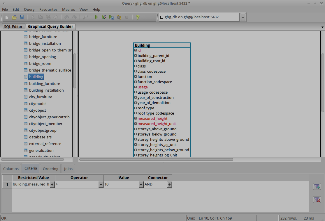
Sql editor window
- is updated based on the graphical query builder
- can send parts of sql query (sub-queries)

Export data with QGIS
Start QGIS
Open QGIS Desktop
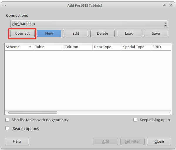
Add new database:
Click on the PostGIS logo (Elephant)
Select 'New'
Add New Database
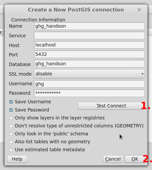
Connect to Database
Query Buildings from DB
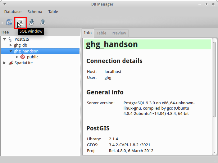
Open 'Database' > 'DB Manager' > 'DB Manager'
Select database 'ghg_handson' and open 'SQL window'
Query Buildings from DB (cont.)
Execute following query:
WITH
groundSurfaces AS (
    SELECT thematic_surface.*
    FROM citydb.thematic_surface INNER JOIN citydb.objectclass
    ON objectclass.id = thematic_surface.objectclass_id
    WHERE classname='BuildingGroundSurface'
),
surfaceGeometries AS (
    SELECT *
    FROM citydb.surface_geometry INNER JOIN groundSurfaces
    ON groundSurfaces.lod2_multi_surface_id = surface_geometry.parent_id
    WHERE geometry IS NOT NULL
),
heights AS (
    SELECT measured_height, surfaceGeometries.*
    FROM citydb.building INNER JOIN surfaceGeometries
    ON building.id = surfaceGeometries.building_id
)
SELECT row_number() OVER() As id, building_id,
measured_height, ST_Force2d(geometry) AS footprint FROM heights;
Query stored in file:
/home/ghg/Desktop/ghg_flux_ws/city_gml/hands-on/select_footprint_height.sql
Query Buildings from DB (cont.)
Select 'Load as new layer'
'Column with unique integer values' : 'id'
'Geometry column' : 'footprint'
Query Buildings from DB (cont.)
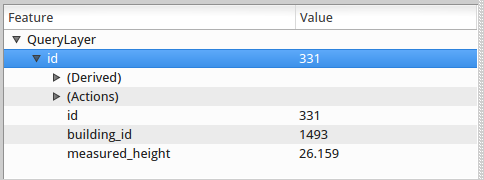
Buildings with Attributes
Buildings with Attributes
Example building:
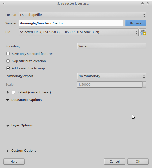
Export to Shape I
Do a right-click onto the layer:
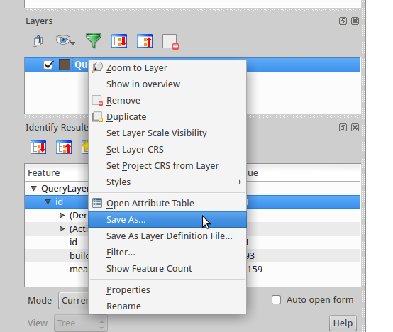
Export to Shape II
Questions?
Live coding examples are provided here:
https://gist.github.com/sluedtke/c69b545a0937f560245f